Rationale
According to Ministerial regulations B.E. 2554, the Land Development Department has duties and responsibilities of: policy definition and land use planning on agricultural areas; soil survey and classification, land suitability definition, control of land use on areas contaminated with chemical wastes, soil and water conservation, soil improvement, map production with regards to land classification, technology transfer from soil development research and, lastly, soil and land use data to increase productivity and sustainable land use practices.
The Office of Engineering for Land Development has duties and responsibilities to implement land and water conservation practices by engineering measures. Water resources for land and water conservation are implemented thru planning, surveying and designing. The engineering infrastructures are constructed to achieve the goal of increasing soil fertility and agricultural productivity.
Objectives
- Main objective: Collecting and reserving water principally for agricultural
purposes on rainfed areas as demanded by local administrations and other
related organizations.
- Minor objective: Maintaining soil moisture in the area beside
the project.Frequently, the water resource itself functions as a sediment trap for
soil conservation purpose.
Categories of Water Resources for Land and Water Conservation
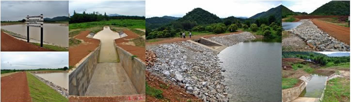
Reservoir: Suitable for hilly or valley site. It can be created by constructing an earth dam across a valley to collect water, while excavating at the upstream side of the embankment will provide higher capacity.
Farm Pond: Suitable for lowland site where runoff can be accumulated at selected locations. It can be created by excavating to a required capacity – then constructing a bank around the pond by the excavated earth.
Lagoon/Swamp Dredging: Sedimentation on natural water bodies, e.g. swamp areas, may cause such sites to be shallow and lose capacity. Increasing the capacity can be done by lowering the bottom level as well as enlarging the catchment level.
Canal Dredging: Shallow canals caused by sedimentation decrease the flow capacity of the channel. Improvement of channel flow capacity can be done by enlarging the channel‘s cross-section area. In addition, weirs or check dams could be constructed for water conservation purpose. Frequently, the banks of the canal can be enlarged and used as farm roads to transport farmers’ inputs and products.
Flood Control: Repetitive flooding in some areas in central Thailand causes great hardships annually. Farmers lose their products and even their plantations. Solving this problem can be done by elevating existing farm roadsto create an embankment system around such areas, which work as water barriers.
Weir: A weir is a structure which is built across a stream to elevate the water level upstream until the water can be diverted into irrigation canals and delivered to agricultural areas directly.
Irrigation Canal: The open channel system usually delivers water from a dam or weir to plantation areas. Moreover, the channel can be lined with concrete or other materials to gain higher efficiency and reduce losses.
Irrigation Piping System: The piping system principally delivers water from a dam or a pumping station to target areas. It is suitable for rolling areas. Selection of pipe material depends on site condition and budget. Normally HDPE, PVC or galvanized steel pipe have been used.
Annual Action Plan of Water Resources for Land and Water Conservation Projects
Fiscal | Amount of Project | Benefited Agricaltural | Construction Budget | Year | (Places) | Area (Km.2) | (Million Baht) | 2009 | 276 | 15,186 | 746.2462 | 2010 | 345 | 5,615 | 828.3828 | 2011 | 424 | 7,730 | 774.8955 | 2012 | 235 | 4,978 | 418.9485 | 2013 | 41* | 660* | 78.6055* | Sum | 1,321 | 34,169 | 2,847.0784 |
* Until April 2013 |
| |