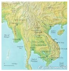
 Thailand straddles the area between two mountain systems: the Central Cordillera and the Cordillera of Annam – these are two of the four systems that fan out southwards from the Yunnan Knot, beginning at about 28˚N latitude. The Central Cordillera gives Thailand its mountains in the north and west, and continues on into the Peninsular South and Malaysia. The Cordillera of Annam provides the mountains east of Thailand, on the boundary with Laos and beyond. The wide depression between these two mountain systems contains the alluvial plains of the Chao Phraya and the Khorat Plain or the Northeast Plateau. Thailand straddles the area between two mountain systems: the Central Cordillera and the Cordillera of Annam – these are two of the four systems that fan out southwards from the Yunnan Knot, beginning at about 28˚N latitude. The Central Cordillera gives Thailand its mountains in the north and west, and continues on into the Peninsular South and Malaysia. The Cordillera of Annam provides the mountains east of Thailand, on the boundary with Laos and beyond. The wide depression between these two mountain systems contains the alluvial plains of the Chao Phraya and the Khorat Plain or the Northeast Plateau.
Structural geology describes this depression on which Thailand is located as part of the Yunnan-Malayan Geosyncline (also designated the Burma-Malaya Geosyncline), which has undergone a long series of structural changes. The evidence suggests that such changes began in the Pre-Cambrian period (570 million years ago), again in the mid-Carboniferous epoch (220 million years ago), at the end of the Triassic epoch (190 million years ago), and towards the end of the Tertiary epoch (1.5 million years ago). Minor changes continue. Each change is believed to bring about the orogeny or epi-orogeny, and metamorphism responsible for the rich mineral deposition in some areas. Plate tectonic theory places Thailand on an inner perimeter of the Southeast Asia Plate, which is being compressed from opposite directions by the Indian Plate to its west and the Philippine Plate to its east. Continuing plate movements exert immense pressure and generate intense heat, capable of transfiguring the tranquil landscape and the subterranean resources.
Based upon the precepts of structural geology, Thailand is divided into four domains:
- the folded belt of mountains in the north, west, and south of the country;
- the folded belt of mountains east of the Chao Phraya Plain, delimiting it
against the higher Khorat Plain and continuing eastward to delineate lower
Kampuchea (Cambodia);
- the Korat Plain with two major basins; and- the Chao Phraya alluvial plain,
with two major basins and a southerly continuation into the Gulf of
Thailand. Moormann and Rojanasoonthon (1968) divided Thailand into six
A) Central Plain
This region occupies the lower central part of Thailand; it is bordered by hilly areas
to the east, north and west, and by the Gulf of Thailand to the south.
The south-central part of the region is occupied by the broad alluvial delta of the Chao Phraya River system, and is known as the Bangkok Plain. Quaternary alluvial
deposits in this Plain are considerable and reach to a depth of well over 300 m in
the Bangkok area. The surface layers of the Bangkok Plain are composed of recent
and semi-recent alluvial deposits. Recent and semi-recent freshwater surface
sediments dominate in the deltas of the major rivers, i.e. the Chao Phraya River
system, the Maeklong and the Pa Sak. Sediments deposited in brackish water
dominate a wide zone in the middle of the plain.The Bangkok Plain and the alluvial valleys of the Ping, Wang, Yom and Nan riversto the north are surrounded by alluvial terraces of different ages. In the southernzone of the Central Plain, at least the lower reaches of these terraces are found to be of marine origin, but farther north they appear to be mainly composed of overlapping alluvial fans from the surrounding highlands. Isolated hills are scattered through the marginal and northern parts of the Central Plain.
B) Southeast Coast
This region is bordered to the north by hills, to the south and west by the Gulf of
Thailand, and to the east by the Banthat Range, which marks the Thai-Kampuchen
border. The east-central part of the region is formed by dissected highlands, which
are a continuation of the Cardaman Mountains of southwest Kampuchea.
Surrounding these highlands are quaternary terraces, mainly of marine origin, in
the western and southern part of the region. Shallow terrace formations, probably
river deposited, are found in the northern part of the region. In the areas dominated
by terrace formations, numerous separate hills and ranges are found, the rock
formations mostly having a northwest-southeast orientation. Stream alluvial plains
are insignificant. Along the coast, however, small non-connecting marine and
brackish water alluvial plains occur. A minor, but nevertheless important, landscape
in this physiographic region is the volcanic plateau, west of Chanthaburi in the Thai.
Mai district
C) Northeast Plateau
The Northeast Plateau is composed mainly of the broad river terraces of the Mekong and its tributaries. This region is bordered to the west by the hills and plateau of the Central Highlands, and to the north and east by the Mekong River. The southern boundary along the Thai-Kampuchen border is marked by the San Kamphaeng and Dong Rek scarps.The main landscape features are the quaternary river terraces, of which three important levels have been recognized, i.e. the low, middle and high terraces. The low terrace is dominant in the catchment area of the Mun River system. The northern part of the plateau is predominantly occupied by middle terraces. Isolated remnants of high terrace are found in many places on the Northeast Plateau. Strings of these remnants seem to accompany the valleys of the Chi and Mun rivers. The largest high terrace areas occur south of Nakhon Ratchasima (Khorat).River alluvium is found along all streams, although the width of these alluvial plains varies considerably. In the wider parts, shallow intermittent lakes are numerous. Isolated low hills and hill ranges occur on the margins of the basin of the Mun River system and in the northern part of the region. Volcanic outcrops and cones are found south of the Mun River.
D) Central Highlands
This region has a complex physiography, including diverging landscape elements such as hills, plateaus, peneplains, and a number of valleys, of which the Pa Sak River Valley is the most important. The Central Highlands are bordered to the east by the Northeast Plateau and to the west by the North and West Continental Highlands, the Central Plain, and the Southeast Coast. The boundary with the North and West Continental Highlands is somewhat arbitrary.The northern portion of the region is mainly composed of hills and more or less strongly incised plateau or peneplains, found at varying levels from approximately 1,200 to about 300 m. The plateau areas are undulating to rolling; the intervening hilly areas are steep, with some very steep areas of craggy limestone buttes. The middle portion of the region is an area of low undulating peneplains, interrupted by steep limestone ridges and buttes. North of Chai Badan, an important volcanic area is found, the central hilly part of which is surrounded by rolling to undulating terrains. The southeastern portion of the Central Highlands includes mainly hilly lands with incised plateaus.
E) North and West Continental Highlands
This region is usually subdivided into two subregions, i.e. the western mountains and the northern hills and valleys. The western mountains consist of part of the rugged Central Cordillera along the Thai-Burma border from about 18˚N in the north to 12˚N, well into the peninsula. Several sub-parallel ridges, divided by narrow and deep valleys are recognized. The westernmost of these ridges is the Tanaosi range, stretching south from approximately 15˚N. East of this ridge, in the catchment area of the Maeklong River, lies an extensive area of rugged limestone hills. An area of north-south oriented hill ranges and foothills is found between the lime stones and the Central Plain. The northern hills and valleys constitute a region of parallel north-south oriented hill ridges and high plateaus, alternating with elongated level-floored basins. In the western part of the sub-region, most of the land is hilly to mountainous, with wide incised plateaus and with narrow inter-montane valleys. To the east, the valleys are relatively more important; the main ones being those of Chiang Mai, Chiang Rai, Lampang, Phrae and Nan. In these basins, several distinct river terraces can be found, of which the higher one usually is strongly eroded. Recent and sub-recent alluvial plains occur in the basins and wider plains. Three larger steep limestone areas and a number of craggy limestone ridges are found in the hilly parts, whereas in Lampang and Phrae provinces, three larger volcanic plateau are observed, with more or less weathered basalt generally at a very shallow depth.
F) Peninsular Thailand
This region is characterized by a number of distinct ranges of hills and mountains en echelon. The two principal ones are the Phuket range on the west of the Peninsula, and the Nakhon Si Thammarat range, starting at about 10˚N on Tao Island, and continuing into Malaysia, west of Padang Besar. The latter range is the “backbone” of the Peninsula.
The landscape between the main ranges is mainly made up of lower hills and of undulating terraces, principally of fluviatile origin. The widest and most pronounced of these depressions stretches from Surat Thani to Trang. On the west coast, the coastal terraces and plains are narrow, with the mountains extending down to the sea in many places. This coast is indented with many drowned estuaries. The east coast is smooth, with wider coastal terraces and plains. The largest coastal plain of Peninsular Thailand stretches from Nakhon Si Thammarat to Songkhla, including important elongated beaches and a large lagoon, the Tha-le Sap or Songkhla Lake. |