Soil map and related
Initially, the reconnaissance soil survey, soil classification and soil mapping in Thailand were carried out for having a broad view of soil resources of the country. Later, these works in a semi-detailed scale were done for provincial level where maps of the 1:100,000 and 1:50,000 scales were completed in 1991. Thereafter, there were soil survey and mapping projects for district level, at a detailed scale of 1: 25,000, focusing to use as basic information for land use and to solve problems on soil resource management within each area, as well as to support various ad hoc projects and soil application maps for various purposes. Thailand’s soil maps consist of national (items 1-6 below), provincial (items 7-10), district and specific project levels (items 11-13).
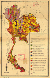
1. The Provisional Soil Map of the Kingdom of Thailand. The soils of Thailand were first mapped in 1946 at a scale 1:1,000,000. Along the western boundary and in other largely uninhabited mountainous sections, where information was absent or scanty, only “guestimates” of soil types and conditions were possible. Nevertheless, this was the first soil map of Thailand based upon actual field work and laboratory research.
In 1949, a soil map was published on a scale of 1:2,500,000 and in 1953 it accompanied an extensive discussion of Thai soils and notes on field work in all sections of the kingdom. Because the published map was on a smaller scale than the original 1946 draft, further generalization and the use of broader soil grouping became necessary. The map published in 1960 is based on the 1949 map, with the original 21 colors translated into a series of black and white patterns.
2. The Kingdom of Thailand General Soil Map. Maps of 1:1,250,000 and 1:2,500,000 scales were produced in 1967 by the collaboration of Dr. F.R. Moorman and Dr. Santhad Rojanasoonthon. They improved and amended the soil maps of Thailand by the application of soil units of the Great Soil Group level and the grouping of two or more groups in the same map unit (relative unit of Great Soil Group). The soil classification system used for that was the one that Dr. R. Dudal and Dr. F.R. Moormann had improved from the soil classification system of the U.S. Department of Agriculture (USDA, 1938) to suit the conditions of soils in South-eastern Asia.
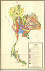
3. General Soil Map of Thailand. Maps of 1:1,000,000 scale were produced in 1979 by Dr. Pisoot Vijarnsorn and Mr. Chingchai Jongphakdee. Soil classification was done with the Soil Taxonomy system. The soil map unit was applied in “Great Group”, emphasized by “Particle-size classes” to characterize the soil texture, particle size, clay and gravel or stones larger than 2 mm mixed in the soil at 25-100 cm depth.
4. General Soil Map of Thailand. Map of 1:1,250,000 scale was published by Dr. Pisoot Vijarnsorn in 1994 by improving the 1:1,000,000 General Soils Map of Thailand in accordance with the soil classification in the soil taxonomy system 1982, to present at the 14th World Soil Congress in Mexico.
5. Soil Map of Thailand. Maps of 1:1,200,000 scale were published in 2002 by using a GIS database of Soil Group map and translate the map unit as named according to the soil taxonomy 1999.
6. General Soil Map of Thailand. Map of 1:1,200,000 scale was published to accompany the document “The Soil Resources of Thailand” in 2002 during the 17th World Soil Congress in Bangkok.
7. Provincial Soil Map. Maps of 1:100,000 scale were initially disseminated in 1971, the map units are soil series and relative units of soil series. They were completely carried out for all provinces in 1984.
8. Soil maps to support land use report in provincial level. These maps (1:50,000 scale) were first distributed in 1990. The maps show the soil boundary by using soil series map units (62 groups) and the soil series relative units. The project has been completed for all provinces except Bangkok.
9. Provincial soil maps of 1:50,000 scale. These maps were produced again by improving provincial level soils information. They were initially disseminated in 2000. They show the information on soil boundary and topography by using soil series, soil types and relative units of soil series as map units. They have been completed for Chiang Mai, Lamphun, Phrae, Uttaradit, Nakhon Ratchasima, Khon Kaen, Kalasin, Maha Sarakham, Roi Et and Narathiwat.
10. Soil maps to support soil survey reports for provincial agriculture, 1:25,000 scale. These maps have been initially disseminated in 2005. They show soil boundaries by using map units of soil series group (62 groups), and the relative units of the soil series group. They have been completely carried out for all provinces.
11. Soil maps to support soil suitability reports for growing economic crops at district level, 1:25,000 scale. This map type has initially been disseminated in 1987. Soil map units are soil series, soil types and soil series relative units. This map type has completely been carried out for totally 142 districts in 43 provinces such as Muang, Ban Pong, Photharam, Chom Bueng Districts of Ratchaburi Province; Bacho, Yi Ngo districts of Narathiwat Province, etc.
12. Soil maps for ad hoc projects. Soil maps were prepared in various scales depending on the type and the purpose to be used, such as ‘Soil Survey on Highland Project’ and ‘Electric Water Pump Project’. Maps units are normally soil series, soil series relative units, or fractional type.
13. Soil maps to use for various purposes. This map type is obtained from the analysis and interpretation of soil data, for example, ‘Map of Carbon in Soils of Thailand’, ‘Map Showing the Distribution of Salt-affected Soils’, ‘Maps Showing Soil Nutrients Levels’, Maps Showing the Distribution of Soil Moisture in Thailand, etc.